Access to Passauer Hütte from the east from Weißbach-Diesbach via Hochgrub
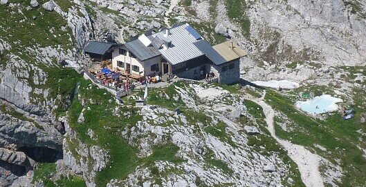
A varied route, initially along well-marked paths in the forest, later along the forest road to Hochgrub and from there onwards across beautiful mountain meadows to the Passau section of the Alpine Club hut in the Mittagsscharte between Birnhorn and Fahnköpfl. This is the only serviced mountain hut in the Leoganger Steinberge and offers an impressive panorama to the south as far as the Hohe Tauern.There is a car park on the right-hand side of the B 311 between Weißbach and Saalfelden (at the wooden bridge). From the car park, walk over the Saalach bridge to the trail junction (Passauer Hütte sign) to the right. Here begins a marked path, the so-called Pfannsteig, which climbs moderately to steeply in serpentines up to the forest path (1 - 1.5 hours). Follow the forest path uphill to the left via a few hairpin bends until you reach a small crossroads. Continue straight ahead along the forest path until after approx. 20 minutes a marked path branches off to the left into the forest. The path leads you through the high forest with interesting flora to the Hochgrub hunting lodge, where you reach the last watering hole up to the lodge. Continue through the forest, cross a beautiful alpine pasture and then climb steeply up to Hochgrub. The path continues only moderately uphill to the Passauer Hütte.
- Start
- Weißbach near Lofer
- Goal
- Passau hut
Best Time of Year
Jän
Feb
Mär
Apr
Mai
Jun
Jul
Aug
Sep
Okt
Nov
Dez
Directions & Parking
Parking:
Coming from Saalfelden or Lofer on the B311, the car park is located on the main road in the Diesbach district of Weißbach.
Car park directly on the Bundesstraße 311.
Public transport: Take the train to Saalfelden or Salzburg and then continue with the Postbus line 260 (Zell am See - Salzburg) to the Weißbach Gramlerbauer stop. From there, walk for about 10 minutes along the cycle path towards Weißbach to the bridge over the Saalach.
Coordinates:
WGS: 47.50327, 12.78038
GMS: 47° 30' 11.8" N, 12° 46' 49.4" E
Car park directly on the Bundesstraße 311.
Public transport: Take the train to Saalfelden or Salzburg and then continue with the Postbus line 260 (Zell am See - Salzburg) to the Weißbach Gramlerbauer stop. From there, walk for about 10 minutes along the cycle path towards Weißbach to the bridge over the Saalach.
Coordinates:
WGS: 47.50327, 12.78038
GMS: 47° 30' 11.8" N, 12° 46' 49.4" E