
Canoeing & Kayaking
River Information for Whitewater EnthusiastsThe Saalach River reveals many different facets while paddling. Calm stretches of the river alternate with challenging sections, offering paddlers a variety of experiences. Between Weißbach and Unken, you’ll experience the river from a perspective that remains hidden when viewed from the shore. Sometimes calm, sometimes challenging: the Saalach offers a variety of routes and difficulty levels. No wonder the Salzburger Saalachtal has been a popular gathering spot for the canoeing and kayaking community for many years.
But first things first: the river in the Salzburger Saalachtal is, as the name suggests, the Saalach. It is about 105 kilometers long and flows through Austria and Germany. It originates in the Kitzbühel Alps; from there, it flows through Saalbach, crosses the Salzburger Saalachtal, and continues on to Bavaria before emptying into the Salzach near Freilassing.
Well-prepared on the Saalach
To help you plan your trip safely, you should check the conditions before every trip. On this page, you’ll find the most important information about the Saalach at a glance:
- Water level
- Current
- Entry and exit points
Canoe Cam on the Saalach
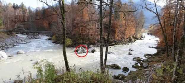
It’s worth checking out the Canoe Cam before every trip. It shows you the current conditions at the Teufelssteg in Lofer and gives you a first impression of the water level, weather, and local conditions. This helps you plan your trip better and assess the situation right away.
Saalach Water Level
Blue: Current water level
Yellow: Proposed pre-alert threshold (250 cm Saalach, Weißbach – 233 cm Saalach, Unterjettenberg)
Red: Proposed alert level (300 cm Saalach, Weißbach – 413 cm Saalach, Unterjettenberg)
In addition to the water level measurements in Weißbach and Unterjettenberg, the water level display at the Teufelssteg provides an additional tool for assessing current conditions on the Saalach. It helps whitewater athletes plan their trips and provides another reference point for assessing the water level.
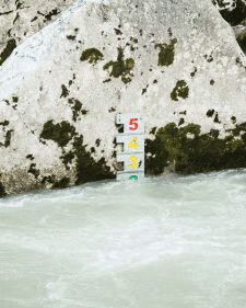
Within the field of view of the Canoe Cam is a water level indicator with a scale from 1 to 5. The indicator is mounted on a rock in the center of the image. To see it, you’ll need to zoom in a bit on the Canoe Cam image.
The scale of the water level indicator:
| Reading | Risk | Meaning |
|---|---|---|
| 1–2 (green) | Low to moderate | Normal conditions |
| 3-4 (yellow) | Elevated | More challenging conditions; increased vigilance required |
| 5 (red) | Very high | Dangerous conditions; rocks may not be visible |
| Not visible | Very high | Water level too high; conditions are particularly critical |
The color scale is intended solely as an additional guide. It does not replace your own on-site assessment and should always be considered in conjunction with water levels and your experience on the specific river section.
An Overview of the Saalach River Sections
|
River Section |
Difficulty Level* |
Length |
Special Features |
|---|---|---|---|
|
Upper Saalach |
WW I-II |
8 km |
The Upper Saalach is the easiest section of the Saalach. It is ideal for beginners and can be paddled practically year-round. |
|
St. Martin Gorge |
WW III+ |
2 km |
The Saalach becomes more challenging. The key section is the “Korkenzieher” shortly after the power plant, which reaches a difficulty level of 4 depending on the water level. Caution: Due to the weir at the gravel plant, the water level is usually very low. In this case, it’s best to launch your boat directly above the “Corkscrew.” After the short gorge, there is a weir with a boat slide. CHECK IT OUT IN ADVANCE. There is a portage option on the left bank. |
|
Middle Saalach |
WW II |
3 km |
The route, which is of moderate difficulty, passes by Camping Grubhof. At the end of this section, the Strubbach flows into the Saalach on the left.
|
|
World Championship slalom course |
WW III-IV |
0.5 km |
The World Championship slalom course offers great eddies and can be navigated along various lines. Navigable year-round, from low water levels up to “medium flow” (Unterjettenberg gauge approx. 40 m³/s, Weißbach gauge approx. 19–25 m³/s and water level indicator in the scale range from 1 to max. 2), this section offers ideal, varied whitewater (WW III–IV). At water levels above mean water, the speed increases dramatically, and the Saalach’s characteristic flow—with a lot of backwater—becomes even more pronounced. You can exit onto the hiking trails along the river at any time. Mastery of the Eskimo roll, along with solid technique, is a prerequisite for paddling this section.
|
|
Teufelsschlucht (Devil's Gorge) |
WW V+ |
2.5 km |
Very challenging. The difficulty level varies depending on the water level, ranging from WW V to unnavigable. The Teufelsschlucht (Devil's Gorge) should only be paddled by experienced kayakers. This section features numerous rapids and cataracts. Please be sure to scout the route beforehand and watch out for dangerous undercuts and hazardous spots. |
|
WW I-III |
15 km |
For the first two kilometers after Au, the Saalach remains fast-moving due to descents and blockages; after that, the river becomes progressively calmer all the way to the exit point in Fronau. |
*The difficulty ratings provided generally apply to average water levels. Depending on the water level, the current, rollers, and eddies can change significantly. This can make individual sections considerably more challenging. Therefore, each run should be reassessed based on current conditions.
Overview of the Saalach with Entry and Exit Points
This overview helps you quickly find suitable entry and exit points along the Saalach and plan your trip more effectively.
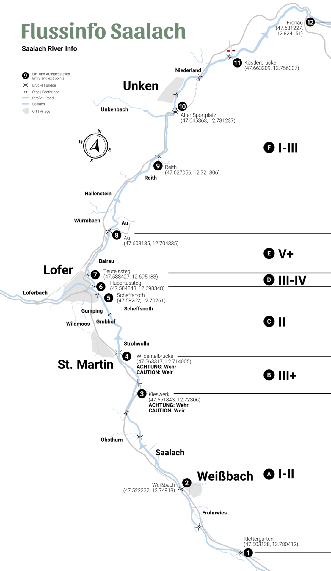
Here You'll Find the Canoeing & Kayaking Routes


The Saalach is one of the most renowned whitewater areas in the Alps and regularly hosts national and international competitions. Whether it’s canoe slalom, kayaking, or whitewater racing — the courses offer ideal conditions for training and top performances.
The slalom course in Lofer, in particular, has made a name for itself in the whitewater scene.
In the event calendar, you’ll also find upcoming canoeing & kayaking events.
Frequently Asked Questions About Canoeing & Kayaking on the Saalach
Is boating on the Saalach River permitted year-round?
Yes. The Saalach is navigable year-round in kayaks, Canadian canoes, and other hard-shell boats.
Are inflatable boats allowed on the Saalach?
No. Inflatable rowing boats are not permitted on the Saalach.
What do the difficulty levels refer to?
The difficulty levels listed apply to medium water levels. Conditions may vary depending on the water level.
Are the water level readings for the Devil's Gorge always reliable?
No. The values from Unterjettenberg and Weißbach are for reference only. The actual conditions should also be assessed on site.
Is the Devil's Gorge accessible by car?
No. This section of the river is currently closed due to the risk of a landslide.
What tools can help with route planning?
To help you plan your trip, we recommend checking the current water levels, the Canoe Cam, and the descriptions of the individual river sections.
Are there any river sections for beginners?
Yes. The Upper Saalach is particularly well-suited for first-time whitewater experiences.
Are there canoeing and kayaking classes for beginners?
Yes. The outdoor activity provider Motion Center offers kayaking courses for various skill levels.


